Looking for something to map?
Mon 09 December 2013
Recently people have released tools to make it easy to find something to map on the OpenStreetMap (OSM) project. If you're looking for something to do take a look at one of these tools:
HOT
The Humanitarian OpenStreetMap Team (HOT) focuses on areas in the world that aren't mapped well (or at all) and where there is a need for a humanitarian effort. If you've been around OSM for a while you'll probably remember reading something about the mapping effort in Haiti after the earthquake back in 2010. The humanitarian effort didn't stop there. Most recently Typhoon Haiyan has left many international emergency responders in need of mapping data to be able to move their resources around and perform damage assessments. Their projects are listed on their website and allow you to checkout a task for mapping or validating other mapping work. As work is completed it goes into the hands of the responders on the ground.
Maproulette
Okay, this is a neat idea. Whenever edits or massive data entries are done there are times when everything doesn't mesh well. Maybe a road crosses another road which looks fine when viewed on a screen but breaks navigation and leads to inefficient routes. These bugs can go unnoticed unless someone tries to use the data and finds a problem or someone might happen to stumble upon the issue. That's where Maproulette comes in. This system gets programmed with a specific problem that needs to be fixed. Right now that problem is the connectivity issue I mentioned. It combs through the OSM database looking for just these issues and records where they are located. A visitor to the site is shown the next error in the list with an offer to bring up an editor so they can either fix the problem or verify a false positive. Because the edits are quick to fix I've been able to knock out forty or more in an hour without much thought. (Hey, some people knit and watch TV, I fix mapping bugs and watch TV!)
Battle Grid
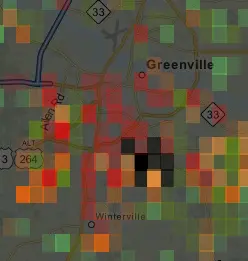
[caption id="attachment_1202" align="alignright" width="142"] Battle Grid, Greenville NC[/caption]
Oh yes, the Battle Grid! Sounds similar to a cage match doesn't it? When the 2012 TIGER mapping data from the US Government was released it was discovered that the quality of the data was much better than the TIGER maps that many of the United States' roadways were originally based upon in OSM. Battle Grid (from Maproulette) combs through the OSM database and compares the TIGER 2012 data to what's in OSM and then shows discrepancies as colored blocks. The redder the boxes the more discrepancies there are in that grid. So a quick look at the map shows you where your mapping skills are most needed. Some additional tools have been created that allow you to overlay the TIGER 2012 data under the OSM data for comparison. This allows you to visually see the problem areas and fix them quickly.
There are other ways to find data that might be missing. Just walking around your community and visually comparing the OSM data to what you see with your own eyes certainly helps. Validating data against satellite imagery is also good. As I wrote about in an early post, collecting points of interest and address information is also quite useful while out and about. Getting involved in OSM is easy and learning how to map isn't difficult either. So get out there and get mapping!